RVery Best Nest

Come join Joe, Mallery & I, as we travel around the USA in our RVery Best Nest. God's Favor has been chasing us down, and we are enjoying all of His blessing's, that He has created for all to enjoy!


Wednesday, April 30, 2014

Mayberry Campground, Mount Airy, North Carolina


                    Monday 4/21/2014

We took Hwy. 421 east to I-77 and headed north.
It was a fairly short drive, but beautiful drive with lots of color.
Blue Ridge Mountains in North Carolina and Virginia ahead of us.
Just south of Mount Airy we took I-74 to Hwy 106 to our Mayberry Campground in North Carolina.
The campground sign tells us to turn on Rustic Village, but the GPS tells us to continue on to Bunker Road, which is the road the campground is located on. Joe had called the campground prior to our travels, and ask if there were any special directions. The girl told Joe to just follow the GPS direction, so we did. It got us there, but we had to make a tight turn. The shortest route was to turn on Rustic Village like the sign said.
This is our current location. We have been here a week, and will be here until next Monday.
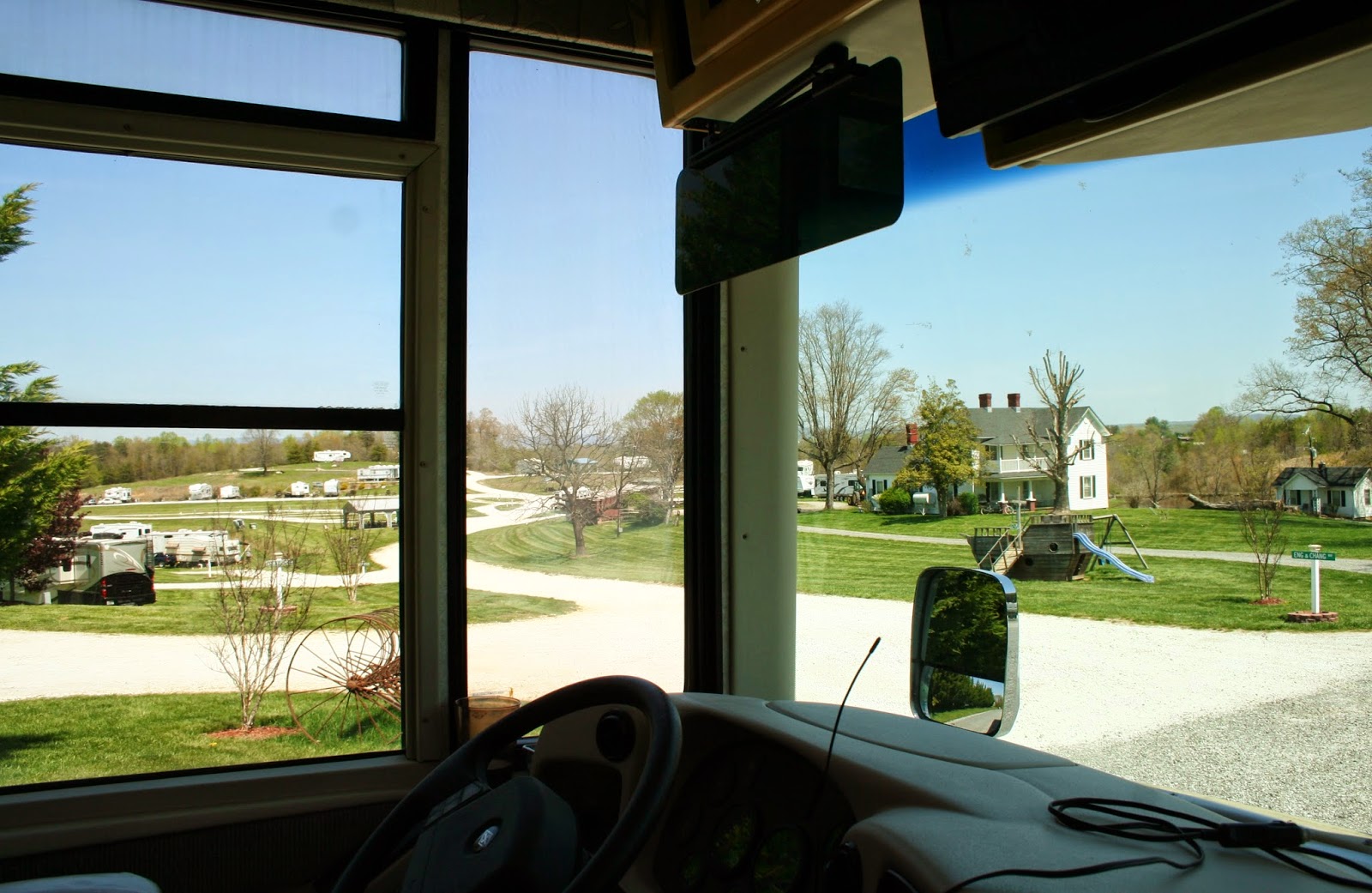
View of Mayberry Campground from the bus. ( We were told that the house in the picture is the place to go for our safe weather  spot by a girl in the office. The next day I heard the girl tell other people to go to Mount Airy Fire Fighters Station. I am going to the house, because that's what they told Joe).
We were given a pull through site #10. The best sites are 2, 3, 4, 5, 16, and 17 because of privacy and nice views, in our opinion.You can request a site when you make your reservations if you know the park, which we didn't. Site 2, 3, 4, and 5 also have sun in the morning on the patio side and shade in the afternoon.
The lower level would be better if tornado storms come through, but they are lower if it rains a lot. There is a pond at the end of the lower level.
We are on the upper level to the left when looking at this picture. You can not see our bus in the picture because we are further to the left in the picture. We had one thunderstorm Monday night, but no tornado warnings. The Appalachian mountains are to the west and north of the campground, which seems to protect this area more from strong storms. This place has been very busy with RV's coming and going daily. It is just off I-77 and I-74, making it a great route for snowbirds going north through to Virginia, West Virginia, and Ohio which is our route. This route also goes to Pennsylvania via Virginia, and West Virginia.

Tuesday, April 29, 2014

W. Kerr Scott Dam And Reservoir, Wilkesboro, N.C.


                       Sunday 4/20/2014

On one of the days that we had drove into Wilkesboro for groceries and a post office stop, I kept my eyes open for churches. I shot a picture of Cornerstone Church, and checked out more about the church later on the internet. On Easter Sunday, we attended this church. We were Blessed with "Higher Ground" presented the service with their awesome music, vocals, and message. After church, Joe told me his lip started to feel like it was getting numb like when you get a Novocain shot at the dentist half way during the service.
I looked at him, and said, "yes your upper lip is swollen" His cheek was also a little swollen. At first we though maybe he was allergic to something he ate for breakfast.
As the day continued, his lip continued to swell. He didn't want to go the the hospital because he felt fine otherwise. I told him if he started to have problems breathing, we needed to head to the hospital immediately.
After lunch, we decide to take a drive to the W. Kerr Scott Dam and Reservoir on the south edge of Wilkesboro.
After driving across the dam, I got this picture.
There were several families enjoying the warm sunny Easter next to the reservoir.
"The 1,475-acre reservoir offers excellent boating, canoeing, kayaking and swimming opportunities. Anglers will find channel catfish, large and smallmouth bass, bluegill, threadfin shad, spotted bass, hybrid striped bass and tiger muskellunge" per internet quote.
As the day continued, Joe's swelling of his upper lip spread to the rest of his lip.
He was getting frustrated with all my pictures, but I felt we should document it.
Left view
 The next morning the swelling was gone. Since then, Joe has ate everything one at a time, that he had ate that morning. Eggs, sausage, English muffin, and jelly. He had salmon the night before, so he also tried that one on another day. Nothing seemed to cause any problems. We have decided something bit him in church that caused the swelling. Funny thing is, he never felt anything bite him. It might always be a mystery.
The MerleFest was to start on the following Thursday, but it cost $40 a per person.  Moravian Falls Campground was costing us $35 a day, which is higher then our budget, so Joe wanted to move on. The camp host told me that in the evenings during the festival, there would be all kinds of talented singing around the campfire, so I kind of thought maybe we should stay. We also didn't see Grandfather Mountain, The Blowing Rock attraction, or get to drive the Blue Ridge Parkway to the famous Linville Viaduct. The week we were here, we had rainy, cold, and windy weather, making it not favorable to spend money for the attractions. Oh well it will give us a reason to come and visit this area again some day, next time in the fall.

Sunday, April 27, 2014

Blue Ridge Parkway To Blowing Rock & Moses Cone House


                    Friday 4/18/2014

The week was slipping by, and we had not had a chance to see everything we wanted to see in the Wilkesboro area. We had had cold, cloudy and rainy weather. On this day it wasn't raining, and the sun was out, so we decided to go site seeing. We drove back toward Boone, and jumped onto the Blue Ridge Parkway.
A lot of the views to the west were rolling hills and farm land, and distant mountains ranges.
This is such beautiful country.
Joe is asked to be a photographer for a family.
After the family leaves, we enjoy one of the many overlooks.
Down the road we see this sign telling us that Daniel Boone used this route to the west. The town of Boone, NC that I recently blogged about, is named after Daniel Boone.
This is the highest overlook elevation that we saw on our drive this day on the parkway.
This part of the parkway was much more comfortable for me, compared to it further south near Marion, NC.
Looking south.
With the zoom lens I am able to see homes below in the foothills.
The mountain layers of the Appalachian.
Zooming and spying on homes below again.
We get off the parkway at the junction of Hwy 321.
The town of Blowing Rock is a very popular mountain town south of Boone, NC and a mile off the Blue Ridge Parkway.
At first we just drove around trying to find a park to eat our sack lunch at. We  had stopped at the Visitor Center and got some maps. The map said there was a park in this area. But it was a housing area, called Laural Park.
We drove down this street and found it was a dead end.The street was a new housing district.
You can buy a lot with great views. I just don't know where you put the house, as there is about 3 feet from the road and then it goes straight down.
"Best Views" lot for sale.
Another lot and it's view. I like great views, but I don't want to live on the edge of a cliff.
I would rather live down there on top of a mountain or hill with land around me and views. But who knows, maybe that house is on a cliff too!
I walked back down the road, while Joe drove back. I really didn't want to even be in the car next to the drop off. I seem to have developed more then usual anxiety of cliffs and drop offs in the car these days!
There was a city park in the down town shopping area, but it was really cold this day, so we just ate our lunch in the car. I had Mallery sit on the floor of the car, so I could balance my salad bowl in my lap. We usually put her in the back seat, but she always manages to jumb back to the front and in my lap again.
Because it was so cold out, I really didn't want to stroll the shopping area with Mallery in her stroller, so we continued to our next stop.
As we left the little town of Blowing Rock, I took this picture of one of the cabins you can rent just blocks from the shopping area. The business is the Mountainair Inn & Cabins. It looked like a really nice place to stay.

One mile from Blowing Rock on the parkway we came the Moses Cone Manor House.
Moses Cone was a textile magnate, who's hobbies including road construction and apple tree cultivation. He had over 75 varieties on his estate.
Today it serves as a gift and craft shop of local artist.


Joe tells me as we look out on the views that he could be talked into doing some updating and work if he had this place. OK, I think we have enough money for that!
In the inside porch, there were local artist demonstrating their talents.
This artist weaves yarns to recreate the scene's in a picture.

Back view from the parking lot showing the upper back and side porches.
I thought we had to go through Blowing Rock to get to Boone, but I realized my mistake after we got there. We needed to go north not south. Oh well it gave me an opportunity to tell you that there is a Tanger Outlet in Blowing Rock.
In Boone we stopped at the Earth Fare store. We had just enough time for shopping at Blowing Rock's down town area or Tanger, or Earth Fare in Boone. Earth Fare is like a Whole Foods, which I love to shop at, so it won our time before we headed back down the mountain to Moravian Falls/ Wilkesboro area.